
Course OverviewBecause the Ascent and Marathon are so unique and so physically demanding when compared to other half-marathons or marathons, having a general understanding of the courses is the key to planning your training.
The Ascent or ascent portion of the Marathon can take as long, or longer, than a full flatland marathon. In fact, many flatlanders find that it can take much longer! On the other hand, if you have trained in high altitude, it is possible to go a little faster than your flatland marathon time during the Ascent. In general, if you live at altitude, go with your flatland marathon time. Otherwise, add 1/2 hour to your flatland marathon time. The average descent time is about 63% of the runner's Ascent time. In other words, the downhill is not free, and there are even a few ups on the way down! What follows is a brief overview of the course. For a more comprehensive version, head to Skyrunner.com. |
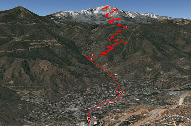
You can view the course in 3D if you have Google Earth.
Google Earth view of the Ascent and Marathon course. |
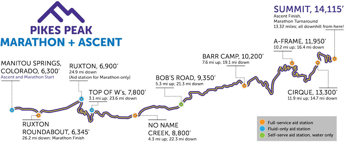
Elevation gain (start to summit) is at 7,815' (2,382m); the start is at 6,300' (1,920m) and the summit is 14,115' (4,302m). The Ascent finish/Marathon turnaround is at approximately 14,050'. The Ascent (and ascent leg of the Marathon) has very few stretches which are not going uphill, with the average grade being 11%.
The races begin in front of the City Hall in Manitou Springs, a city of some 5,000 population, located approximately 6 miles west of Colorado Springs, Colorado. While both races begin in the city (and the Marathon finishes in the city) the majority of both races are run on Barr Trail in Pike National Forest. Barr Trail is a US Forest Service trail that is on the east face of Pikes Peak. The race courses do not use any part of the famed Pikes Peak Highway (which is on the north and west flanks of the mountain). The trail is often narrow, winding, and may be gravel, rocks or dirt with sharp turns and abrupt changes in elevation or direction. However, there are no exposed ledges, so there is little danger of falling off the trail!
From the Manitou Springs City Hall, the races proceed west on Manitou Avenue for 0.42 miles to Ruxton Avenue. At Ruxton, the course turns west for 0.8 mile to (and past) the Cog Railway Depot to Hydro Street. At this point there has been an elevation gain of approximately 300' for an average grade of 4.5%. At .23 of a mile past Hydro Street, or 1.45 miles total, the asphalt ends, and the course continues on a dirt/gravel road which parallels Ruxton Creek. At the end of the dirt/gravel road, there is a fenced area, and the course stays to the north side of the fence before meeting up with a small trail on the right. This trail, commonly referred to as the “spur trail,” connects to Barr Trail in .1 of a mile. From this point to the summit at 14,115,' the course follows Barr Trail. The width of the trail will vary as will the grade (steepness) and surface (footing).
From Hydro Street to No Name Creek is 3 miles with an elevation gain of 2,150' for an average grade of 13.4%. From No Name Creek to Barr Camp is about 3.3 miles with an elevation gain of 1,450' for an average grade of 8.3%. This is the fastest section of the course and even includes several slight downhill sections roughly 1.25 miles above No Name Creek. Barr Camp to the A-frame shelter at treeline is another 2.6 miles and 1,800' in elevation gain for an average grade of 13.1%. From the A-frame to finish/turnaround (~14,050') is about 3.1 miles with an elevation gain of 2,050' for an average grade of 12.4%
The footing, or surface, of the trail does vary. In the forested sections, it is primarily decomposed rock with a mixture of dirt and loose gravel on the surface with the occasional root or rock protrusion. Above treeline (that is, above the A-frame shelter) the trail is primarily loose gravel with one short section of broken rock (generally referred to as rubble), and the section known as the 16 Golden Stairs being gravel with frequent step-ups of some 10 to 15 inches (the Golden Stairs refers to the 32 switchbacks remaining to the summit). In general, the condition of Barr Trail is excellent thanks primarily to the Friends of the Peak and the Pikes Peak Trail Dogs led by Gail Allen.
The course for the 26.21 mile Pikes Peak Marathon® covers the same route as the 13.32 mile Pikes Peak Ascent® race but returns down the trail from the summit and finishes at Ruxton and Manitou Avenues in Manitou Springs.
The Pikes Peak Marathon & Ascent are operated under a special use permit from the Pike National Forest.
Aid Stations
Throughout the course, there will be water, Skratch, and snacks like fruit, candy, and pretzels. New in 2024 Neversecond will be equipping the Barr Trail aid station with energy gels for all runners (with additional gels on the Summit for Marathon runners). Runners are encouraged to take in as much fluid as possible, not only water, but electrolyte replacement drinks. Recent data has shown that some competitors may become extremely ill, not just from dehydration, but from low sodium caused by electrolytes being washed out of the system. Drink your Skratch!
With but one really poor fire road going anywhere near Barr Trail, just HOW is all that drinking water provided at the aid stations?
With but one really poor fire road going anywhere near Barr Trail, just HOW is all that drinking water provided at the aid stations?
- Barr Camp and the A-Frame - volunteers arrive Friday and spend the weekend on the mountain and hand pump water through a filter system.
- Top of W's, No Name Creek, Bob's Road, and Cirque - the water is transported by vehicle to points on the mountain where it then is piped (through several thousand feet of hose put in place by the operations team and other volunteers) to aid stations.


Course Cutoff Times
Aid Station |
Distance, Elevation |
Elapsed Time |
No Name |
4.3 mi, 8,800' |
1:40:00 |
Barr Camp |
7.6 mi, 10,200' |
3:10:00 |
A-Frame |
10.2 mi, 12,000' |
4:30:00 |
Summit |
13.3 mi, 14,115' |
6:30:00 - Ascent Finish 6:15:00 - Marathon Summit Turnaround |
Marathon Finish |
26.21 mi |
10:00:00 |
Runner Transportation Back to Manitou Springs
|
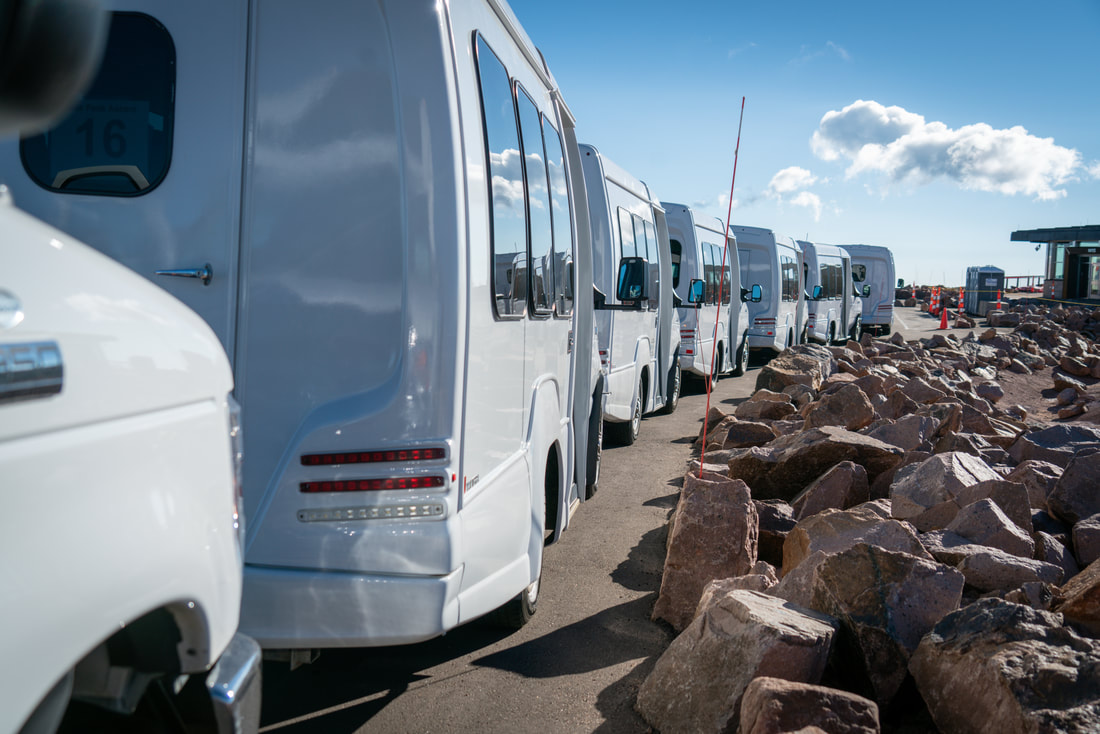
Ascent runners will be transported from the summit of Pikes Peak back to Manitou Springs. Every effort is made to transport runners off the summit as quickly as possible. It is recommended that runners use sweat check to have dry gear available after crossing the finish line at the summit. Bags will be marked according to your bib number. Some items that might be nice once you finish include a dry windproof jacket, a dry shirt, gloves, and money for Summit House goodies.
The summit shuttle busses stop at Glen Cove where runners are transferred to larger busses that return to Memorial Park. |
|
Trail Passing
Much of the trail is narrow, so passing is difficult or impossible. Experienced runners will advise you not to pass frequently as the result is, in most cases, that you will expend too much energy and then slow down (only to be passed by those you may have just passed). On some sections of the trail, your best bet if you get caught in traffic is just to relax and wait for a wider portion of trail! This is particularly true once you leave the road and until you almost get to No Name Creek. There is plenty of time, and room for passing above No Name Creek — A least until you get to Barr Camp.
Finally, many employ a strategy of going out fast on the road to get ahead of the traffic. However, the problem with that strategy is that everyone knows it, so those that try this often just blow their race and become the very people they were trying to get ahead of. You have to find a balance between not giving up places and not blowing your race!
Trail Running Etiquette
- Do not run or walk abreast in pairs or groups when it will impede other runners.
- Stay on the right side of the trail so other runners may pass.
- Downhill marathon runners have the right of way — uphill runners must yield to downhill runners.
Weather
In a word, UNPREDICTABLE. Pikes Peak can create unusual and rapid weather changes above tree line. Temperatures may vary as much as 50° F (23° C) between Manitou Springs and the upper parts of the mountain. This is why the mandatory gear requirements are so important. Historically, the Pikes Peak races have had years with snow on the summit, blue sky days, and everything in between. Each year, the race committee is in constant communication with weather experts. You can have confidence that the race committee will make safety the utmost priority and race day decisions will protect runner and volunteer safety.
Some weather specifics: average temperature at the start line at 7am is usually 60° - 70° F (15 - 21° C) and at the summit 35-55° F (2-12° C) by 10am, not counting wind chill factors. Late afternoon temperatures in Manitou Springs in September can reach the 90°s F, while above tree line storm cells can drop ambient temperatures into the 30°s F. Humidity is normally <15% (usually much less at higher elevations).
Some weather specifics: average temperature at the start line at 7am is usually 60° - 70° F (15 - 21° C) and at the summit 35-55° F (2-12° C) by 10am, not counting wind chill factors. Late afternoon temperatures in Manitou Springs in September can reach the 90°s F, while above tree line storm cells can drop ambient temperatures into the 30°s F. Humidity is normally <15% (usually much less at higher elevations).
Lightning
Lightning deserves its own heading separate from weather because it can come out of the blue! Indeed, the possibility of lightning poses the single greatest threat to runners, especially above tree line. If you are caught in severe lightning, it is best for a group to spread out and crouch down with your feet planted on anything that will insulate you from the ground (jacket, fanny pack, etc.). Try not to be the tallest object in the vicinity.
Lightning has caused the race committee to turn runners back down the mountain at tree line. Our partners with El Paso County Search and Rescue receive up-to-the-minute weather data. Please follow any directions the race committee, volunteers, and Search and Rescue give you regarding lightning and safety instructions.
Click here for a photo of what happens to your shoes when you are close to a lightning strike while running.
Spectators
Be at the start at 600 Manitou Avenue to see the runners off on both Saturday and Sunday. Race start is scheduled for 7:00 AM.
To view the finish of the Pikes Peak Ascent or the turnaround for the Marathon, there will be large screen to view the fixed camera live stream of the race in the Expo areas in Manitou Springs.
A limited number of Pikes Peak summit parking spaces will be released by the race organization for viewing the Ascent finish. These ticketed parking spaces are released late summer. Ascent runners will receive an email notification when parking spaces are available for purchase. The race organization does not provide transportation for spectators from Manitou Springs to the summit or back down.
The finish of the Pikes Peak Marathon is on Manitou Avenue at the intersection of Ruxton Avenue and next to Soda Springs Park. We ask that all spectators respect the police and follow their instructions regarding crowd control.
For more information on the Pikes Peak Highway:
Pikes Peak Highway: 719-385-7325 / 1-800-318-9505

©
Pikes Peak Marathon